| Description | |
|---|---|
|
(a)
|
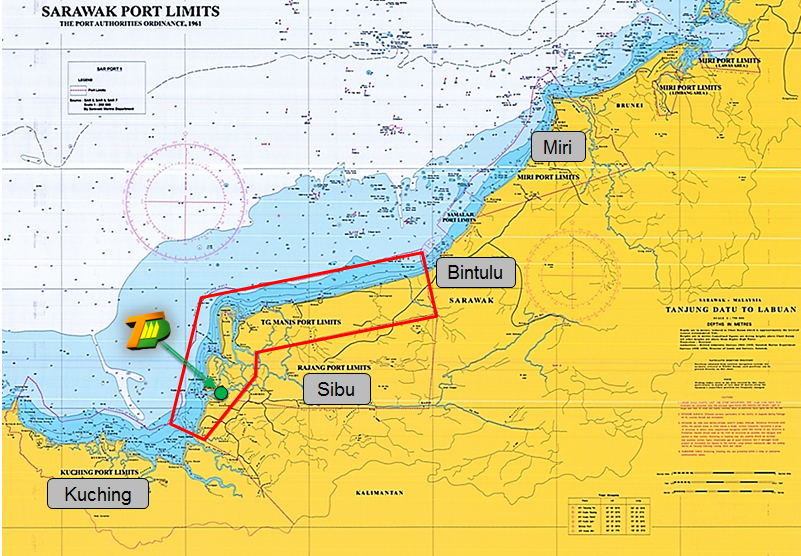
Commencing from a point at Tg. Sirik at latitude 02° 48′ 28”.170 North, longitude 111° 20′ 13”.562 East ;
|
|
(b)
|
thence in a southeasterly direction to a point north of Pulau Patok at latitude 02° 46′ 04”.352 North, longitude 111° 24′ 11”.693 East ;
|
|
(c)
|
thence crossing Muara Lassa to a point at latitude 02° 44′ 59”.769 North, longitude 111° 30′ 06”.419 East ;
|
|
(d)
|
thence along the Coastal High Water Line in northeasterly direction to Tg. Budu at latitude 02° 51′ 00”.428 North, longitude 111° 38′ 56”.531 East ;
|
|
(e)
|
thence crossing Kuala Igan to Tg. Duga at latitude 02° 50′ 12”.988 North, longitude 111° 40′ 33”.117 East ;
|
|
(f)
|
thence along the Coastal High Water Line in northeasterly direction to meet the limit of Bintulu Port at latitude 03° 08′ 23”.720 North, longitude 112° 57′ 52”.467 East ;
|
|
(g)
|
thence following the limit of Bintulu Port in semi circle to a point at latitude 03° 19′ 44”.523 North, longitude 112° 54′ 35”.836 East ;
|
|
(h)
|
thence an imaginary line parallel to the coastal line, maintaining at all places alongside the coast a distance of twelve nautical miles in southeasterly direction to a point at latitude 01° 52′ 29”.531 North, longitude 110° 53′ 14”.076 East ;
|
|
(i)
|
thence in a southeasterly direction to Tg. Batang Marou at latitude 01° 45′ 58”.047 North, longitude 111° 04′ 47”.965 East ;
|
|
(j)
|
thence in a northerly direction along the Coastal High Water Line crossing Kuala Kabong and Kuala Nyabor to Tg. Selalang at latitude 02° 05′ 46”.092 North, longitude 111° 12′ 32”.369 East ;
|
|
(k)
|
thence crossing Kuala Rajang to Tg. Jerijeh at latitude 02° 09′ 07”.140 North, longitude 111° 09′ 35”.994 East ;
|
|
(l)
|
thence along the Coastal High Water Line in northeasterly direction to Kampung Belawai at latitude 02° 14′ 06”.090 North, longitude 111° 12′ 45”.461 East ;
|
|
(m)
|
thence crossing Kuala Belawai to Tg. Manat at latitude 02° 14′ 29”.697 North, longitude 111° 11′ 25”.426 East ;
|
|
(n)
|
thence in a northerly direction along the Coastal High Water Line to Tg. Pasir at latitude 02° 26′ 37”.240 North, longitude 111° 14′ 25”.012 East ;
|
|
(o)
|
thence in a northerly direction along the Coastal High Water Line to Tg. Pasir at latitude 02° 26′ 37”.240 North, longitude 111° 14′ 25”.012 East ;
|
|
(p)
|
thence due north along the Coastal High Water Line on the east coast of Pulau Bruit back to Tg. Sirik at latitude 02° 48′ 28”.170 North, longitude 111° 20′ 13”.562 East, being the point of commencement.
|
| Description | |
|---|---|
|
(a)
|
Commencing from a point at Tg. Sirik at latitude 02° 48′ 28”.170 North, longitude 111° 20′ 13”.562 East ;
|
|
(b)
|
thence in a southeasterly direction to a point north of Pulau Patok at latitude 02° 46′ 04”.352 North, longitude 111° 24′ 11”.693 East ;
|
|
(c)
|
thence crossing Muara Lassa to a point at latitude 02° 44′ 59”.769 North, longitude 111° 30′ 06”.419 East ;
|
|
(d)
|
thence along the Coastal High Water Line in northeasterly direction to Tg. Budu at latitude 02° 51′ 00”.428 North, longitude 111° 38′ 56”.531 East ;
|
|
(e)
|
thence crossing Kuala Igan to Tg. Duga at latitude 02° 50′ 12”.988 North, longitude 111° 40′ 33”.117 East ;
|
|
(f)
|
thence along the Coastal High Water Line in northeasterly direction to meet the limit of Bintulu Port at latitude 03° 08′ 23”.720 North, longitude 112° 57′ 52”.467 East ;
|
|
(g)
|
thence along the Coastal High Water Line in northeasterly direction to meet the limit of Bintulu Port at latitude 03° 08′ 23”.720 North, longitude 112° 57′ 52”.467 East ;
|
|
(h)
|
thence in a southeasterly direction to a point east of Batang Tatau at latitude 02° 47′ 27”.315 North, longitude 113° 02′ 13”.818 East ;
|
|
(i)
|
thence in a southeasterly direction to Tg. Gir at latitude 02° 28′ 29”.791 North, longitude 111° 35′ 21”.621 East ;
|
|
(j)
|
thence in a southeasterly direction to Loba Semah at latitude 02° 15′ 50”.955 North, longitude 111° 34′ 53”.707 East ;
|
|
(k)
|
thence in a southeasterly direction to a point southwest of Sarikei at latitude 02° 03′ 53”.511 North, longitude 111° 25′ 44”.821 East ;
|
|
(l)
|
thence in a southeasterly direction to a point south of Batang Kerian at latitude 01° 43′ 31”.390 North, longitude 111° 09′ 27”.842 East ;
|
|
(m)
|
thence in a northwesterly direction to Tg. Batang Marou at latitude 01° 45′ 58”.047 North, longitude 111° 04′ 47”.965 East ;
|
|
(n)
|
thence in a northerly direction along the Coastal High Water Line crossing Kuala Kabong and Kuala Nyabor to Tg. Selalang at latitude 02° 05′ 46”.092 North, longitude 111° 12′ 32”.369 East ;
|
|
(o)
|
thence crossing Kuala Rajang to Tg. Jerijeh at latitude 02° 09′ 07”.140 North, longitude 111° 09′ 35”.994 East ;
|
|
(p)
|
thence along the Coastal High Water Line in northeasterly direction to Kampung Belawai at latitude 02° 14′ 06”.090 North, longitude 111° 12′ 45”.461 East ;
|
|
(q)
|
thence crossing Kuala Belawai to Tg. Manat at latitude 02° 14′ 29”.697 North, longitude 111° 11′ 25”.426 East ;
|
|
(r)
|
thence in a northerly direction along the Coastal High Water Line to Tg. Pasir at latitude 02° 26′ 37”.240 North, longitude 111° 14′ 25”.012 East ;
|
|
(s)
|
thence due east and crossing Kuala Paloh to Tg. Sedi of Pulau Bruit at latitude 02° 26′ 35”.004 North, longitude 111° 17′ 37”.937 East ;
|
|
(t)
|
thence due north along the Coastal High Water Line on the east coast of Pulau Bruit back to Tg. Sirik at latitude 02° 48′ 28”.170 North, longitude 111° 20′ 13”.562 East, being the point of commencement.
|
